Unmanned Experts Works with Las Vegas Metropolitan Police Department to Demonstrate Unmanned Aircraft Systems Role in Accident Analysis
- September 20, 2016
- Posted by: Drew Jurkofsky
- Category: Blog
Las Vegas, Nevada. Serving a population of over two million spread across eight thousand square miles, the Las Vegas Metropolitan Police Department faces daily challenges in conducting prompt, thorough investigations on the over 240 traffic accidents that occur annually. Teams from the LVMPD Accident Investigation Detail must travel long distances to accident sites, then complete detailed assessments in situations where officers and investigators are at risk from continuing traffic flow and are under pressure to quickly re-open closed routes.

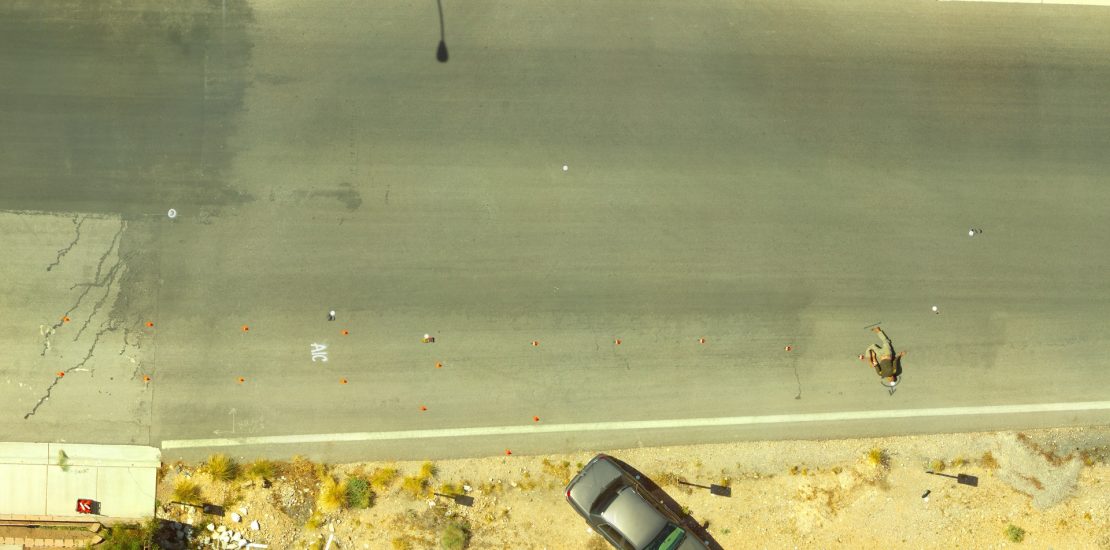
The Las Vegas Metropolitan Police Department Created a Mock Accident for UAS Analysis
Thus the LVPD Traffic Bureau welcomed a proposal from Unmanned Experts Inc., a Denver-based unmanned aircraft systems technology applications company, to conduct an exercise that would compare the process of recording and measuring evidence at a typical accident scene using traditional methods with a process that used an unmanned aerial vehicle (UAV / drone) to gather evidence from a precision flight pattern above the accident scene.
Unmanned Experts did prior work with the National Institute of Justice in 2014 to demonstrate UAS applications in accident scene diagramming, and it has used this experience to refine the techniques. The joint LVMPD-Unmanned Experts exercise was designed to compare the steps, timing, and data detail and accuracy of a ground-based team using terrestrial tools with a drone-flying team that featured forensic aerial mapping.
For the exercise, conducted during a day in March, the LVMPD’s Accident Investigation Detail, which consists of both ‘Hit & Run’ and ‘Fatal’ teams, constructed an accident scene on a closed suburban road that simulated an automobile having hit a pedestrian and running off the road. First the accident scene was diagrammed by the LVMPD using a traditional, ground-based GPS total station.
Then Drew Jurkofsky, Unmanned Experts’ Chief Knowledge Officer, and Dave Prall, Unmanned Experts’ Special Projects VP, launched an Aeryon SkyRanger UAS, a high-spec commercial quad-copter with an all-weather design and extended flight endurance. The SkyRanger was quickly positioned over the accident scene at an altitude of about 20 meters. It was then programmed to fly a grid pattern over the scene with the camera pointed straight down. Three additional missions were flown with the camera taking oblique images at 20, 15 and 10 meters. Finally, ground images were collected using a Nikon DSL camera.

UAV Images of the Mock Accident Site Were Processed to Create 3-Dimensional Point Clouds
Following the flight, the Unmanned Experts team processed the images using Pix4D software, which resulted in an overall scene orthophoto and 3-dimensional point cloud. The point cloud allows for precise calculations of distances between points of interest at the scene. The point cloud points and distances were compared to ground-based total station measurements to determine the accuracy of aerial photogrammetry.
At the recent WREX 2016 conference in Orlando, Jurkofsky discussed the preliminary results of the project and the measurements. “Our key findings are that very accurate horizontal and vertical measurements of the scene can be obtained quickly. When targets are used on the ground to identify evidence, overall positional accuracy is between 1.5 and 3.5 centimeters. Without the use of targets, positional accuracy is between 2.5 and 5.5 centimeters. Accuracy increased with the addition of oblique image sets. With automated flight profiles, this coverage is easy to get quickly.”
He went on to note that leveraging UAVs for accident analysis can also provide a huge safety factor to police investigators. According to the National Law Enforcement Officers Memorial Fund, the number one cause of death for police officers since 2005 has been traffic-related accidents with nearly 20% of the deaths attributed to officers standing in the roadway. Accident investigations that leverage the speed of UAVs to gather data can reduce officers’ exposure to this risk considerably.
“The Las Vegas Metropolitan Police Department is leading the way with its evaluations of UAVs,” said Jurkofsky. “We’re getting inquiries from many local and state police agencies asking about how to incorporate this technology into their accident and crime teams. We see drones becoming an essential tool for quick, safe, and legally sound investigation support.”