Drone use will rise among Larimer County law, fire agencies
- June 22, 2017
- Posted by: Drew Jurkofsky
- Category: Blog
Larimer County, Colorado. A world in which local law enforcement agents and firefighters use unmanned aircraft to gather crime scene evidence, monitor hazardous accidents and measure fire conditions has arrived.
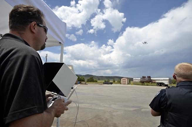
Representatives from emergency response agencies across Larimer County gathered Thursday at Poudre Fire Authority’s training grounds in Fort Collins to demonstrate how drones can be used to enhance public safety in a variety of situations.
Expediting the process of gathering evidence in serious motor vehicle accidents, measuring the heat produced by flames in a structure fire, identifying chemicals spilled in a train derailment and mapping routes to locate stranded hikers were among the applications for drone use by local fire, police and rescue crews.
Soon, agents from Poudre Fire Authority, Loveland Fire Rescue Authority, Larimer County Sheriff’s Office, Fort Collins Police Services, Loveland Police Department, Larimer County Search and Rescue and Colorado State University Police Department will be cleared to fly drones for public safety purposes.
The drone pilots from each agency will combine to form the Larimer County Unmanned Aircraft System Team, which will officially be able to start employing the services offered by drone technology July 1, said Fort Collins police Lt. Jeremy Yonce.
Police use
One of the more impressive potential applications of drones is gathering vehicle crash scene data in a matter of minutes. Compare that to the hours currently needed by police to take measurements with technology operated by manpower.

Roads may be able to reopen hours sooner following an accident than in the past, when police have been required to gather data with hand-held laser devices at each point of interest to determine vehicles’ paths of travel during crashes.
“A single flight gets the 150 to 200 data points we normally take, and possibly millions more,” said Fort Collins police officer Drew Jurkofsky. “And it takes less than 10 minutes.”
The images rendered with drones’ in-flight cameras can create 3-D mapping, allowing a judge or jury to view more accurate evidence than ever before to determine possible criminal charges to bring against anyone involved in a serious accident.
Loveland’s police department is currently in the process of sending an officer through courses to become a certified drone pilot, said Loveland fire department spokesman Scott Pringle.
Firefighter use
Part of Thursday’s demonstration included the use of infrared camera technology equipped to drones flown by firefighters to measure heat produced by a fire.
Drones also were used to approach a train car staged as part of a mock derailment in order to identify the train car’s placards to determine what it may be carrying, or if any materials are leaking.
In both instances, Pringle said the goal is to gather as much information as possible about any emergency scene while firefighters are inside a burning building or before sending them near leaked hazardous substances. Drones can also be used to assist with follow-ups and fire investigations.
Essentially, the drones allow a probe into a scene without any risk to people, and relay data on fires while firefighters combat them.
Currently, the sole certified drone pilot in Loveland’s fire department is Engineer Josh Valerio, but Battalion Chief Tim Smith along with Pringle and a Loveland police officer begin courses next week to also become licensed drone operators.
What about privacy?
The idea of police and other authorities flying unmanned aircraft with the ability to capture photographs over private property likely gives some residents obvious concerns regarding government intrusion.
However, Lt. Yonce said each agency of the Larimer County Unmanned Aircraft System Team has agreed to standard self-regulations that go above and beyond the current legal requirements of private citizens operating drones.
A search warrant or a property owner’s voluntary consent will be required for a police drone pilot to take any still pictures or videos of any private residence or property, Yonce said.
Additionally, drone operators are legally obligated to fly within their lines of sight, meaning an aircraft cannot travel to the point where it is invisible to its pilot.
That limits police and other officials to flying drones only when they are on scene, and prevents remote evidence-gathering. Available battery power on the drones disallows flights longer than about 20 minutes, anyway.
“The intent was never to find backyard marijuana grows,” Yonce said.
For each drone mission, the agency flying the aircraft will keep any pictures or videos taken in-flight, and the public release of those files will be subject to the corresponding agency’s current standards for sharing digital evidence, Yonce said.
More about the drones
• Each of the previously mentioned agencies in the county has purchased at least one drone at a price between $3,000 and $5,000. They are the Inspire models made by the company DJI.
• Each drone flight will require two officials, one to steer its movement and another to serve as a spotter.
• Police department drones will hold blue decals with replica badges, and fire department drones will have red decals. A pair of red lights marks the front of each drone, and a pair of green lights marks each one’s rear.
• Their maximum altitude is about 400 feet, but a height of 60 to 90 feet is considered optimal for quality photos.
• Infrared camera technology costs between $6,000 and $10,000 to add to each drone. So far, Loveland’s fire department has not purchased such technology, but may do so in the future.
• Drones can withstand winds up to about 18 miles per hour without wavering.
• Flight routes, a landing spot and the number of in-flight photos to take can be pre-programmed into the drones for a hands-free flight. A circular route or a cross-grid route can be programmed.